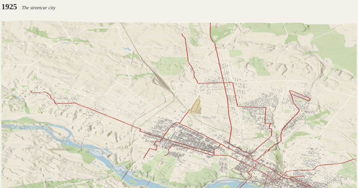
Richmond's streetcars, 1925. A frame 13.6 km across and 12.4 km deep (168.64 km²), centered on 37.5605°N, 77.4705°W.
The year 1925: The streetcar city how time is drawn →
Car lines as Harland Bartholomew & Associates mapped them for 1925: within the city limits of the day, with the Lakeside and Westhampton lines running on beyond.
Measured: 14,454 buildings standing today that had been built by 1925. Their years: 13,796 from the city assessor’s year built, 647 from OpenStreetMap’s start_date, 11 curated. Anything demolished since is missing unless traced or curated below.
Traced: 1,257 buildings that no longer stand, traced from Sanborn fire-insurance maps and drawn in the maps’ own colors (pink brick, yellow frame, blue stone, gray iron). Each appears from the first map that shows it, though it may be older. When it went: 385 by a later map that no longer shows it, 56 by the year the building now on the site went up, 84 by an expressway through the site, and 732 assumed gone by 1960. Heights are guessed from the material: brick and stone three stories, frame two.
Streetcars: 16 car lines in red, each placed on today’s streets from the corners its sources name (listed below), with 78 cars along them, all drawn 3 times life size so they read at this scale. Small streets are drawn only where a house of the year stood nearby: 9,479 laid out since are left off.
Curated for this year, from published sources; positions are drawn from today’s street grid and published dimensions, not surveyed:
- Westhampton line (1901–1947). West on Floyd Avenue from Robinson Street to the belt line railroad, under it in a tunnel, then a little north to Grove Avenue; out Grove to Three Chopt Road; then on its own right-of-way beside Three Chopt to Towana Road, and on (the line of today's Campus Drive) to Westhampton Park, which became the University of Richmond's campus in 1914. The right-of-way beside Three Chopt is drawn along the road itself. [1] [2]
- Belmont line (1895–1949). The Broad Street line's extension west from Robinson Street to Sheppard, south to Cary, later carried on eleven blocks to Garrett Street. Which street carried the last stretch is read from the 1925 plate's 'Belmont' label. [1] [2]
- Broad Street line (1888–1949). Broad Street, the spine of the system, from the Belmont line's turn at Sheppard Street east to Church Hill. The east end is approximate. [1] [2]
- State Fair Grounds spur (1906–1941). The 1925 plate shows a short spur north from Broad Street ending in a loop. It is drawn here up the Boulevard to the State Fair Grounds (1906–1941, on the site of The Diamond); which street the spur took is not certain. [1] [2] [3]
- Main Street line (1888–1949). West Main Street, which the line turned into a commercial street through the Fan, east to Shockoe. The west end is approximate. [1] [2]
- Harrison Street line (1890–1949). A crosstown link on Harrison Street between the Main, Floyd and Broad lines, as the 1925 plate shows it. [1]
- Reservoir (Byrd) Park line (1895–1949). Down Robinson Street to Reservoir Park (Byrd Park), one of the trolley's favorite destinations, along Lakeview Avenue as the 1925 plate labels it. The far end is approximate. [1] [2] [3]
- Clay Street line (1888–1949). Sprague's first line of 1888 ran from Church Hill to Clay and Hancock Streets; the 1925 plate still shows Clay Street. The ends are approximate. [1] [2]
- Brookland and Lakeside line (1891–1949). Over the First Street viaduct (1891) into Barton Heights, then west along Brookland Park Boulevard, north up the median of Chamberlayne Avenue, west on Laburnum and north on Hermitage Road to Lakeside Park and Lewis Ginter's Lakeside Wheel Club. The run beyond Hermitage Road along Lakeside Avenue is approximate. [1] [2] [3]
- Highland Park line (1893–1949). North on Fifth Street over the Northside Viaduct (1892) to Chestnut Hill and Highland Park, and after 1908 round a loop by Meadowbridge Road, Milton Street and Highland Street (the cross street joining them, Second Avenue here, is approximate). The Hull Street–Highland Park line was Richmond's last: the last car ran on 25 November 1949. [1] [2] [3]
- Marshall Street line (Fulton) (1911–1949). Across Shockoe Valley on the Marshall Street Viaduct (1911, since demolished: drawn straight) from College Street to 21st Street at Jefferson Park, out Marshall Street, and down to Fulton along Williamsburg Avenue. The route from Marshall Street down to Fulton is approximate. [1] [2]
- Venable Street line (1888–1949). North on 17th Street, east along Venable Street through Union Hill, and up 25th Street to Nine Mile Road, the road the Seven Pines line took out of the city (chartered along 25th to 29th Streets and Nine Mile Road). The federal government bought the Seven Pines line in 1918 for a wartime plant; how far cars ran out Nine Mile Road in 1925 is not certain. [1] [2] [3]
- Jefferson Avenue line (1890–1949). Up 21st Street and out Jefferson Avenue past Jefferson Park, one of the trolley's pleasure grounds, as the 1925 plate shows it. [1] [2]
- Hull Street line (1888–1949). Over the Mayo Bridge into Manchester and out Hull Street. Its last car, No. 408 on the Hull Street–Highland Park run, ended Richmond's streetcars on 25 November 1949. The outer end is approximate. [1] [2]
- Forest Hill line (1890–1934). South over the river (the free bridge at Ninth Street), down the median of Semmes Avenue through Woodland Heights, and out Forest Hill Avenue to Forest Hill Park and its amusement park, the most popular trolley destination of all. VEPCO proposed taking up the Semmes Avenue tracks in 1933. [1] [2] [3] [4]
- Richmond–Ashland Railway (1907–1938). The interurban to Ashland, built as the Richmond and Chesapeake Bay Railway (1907) and run as the Richmond–Ashland Railway from 1919 to 1938: from its terminal at Broad and Laurel Streets (814 West Broad), over a half-mile concrete trestle across Bacon's Quarter Branch (drawn straight), then up Brook Road and on to Ashland. [1] [2] [3]
- Virginia State Fair Grounds (1906–1941). The State Fair grounds at the tip of the triangle between the Boulevard and Hermitage Road, from the revived fair of 1906 until the fair moved out in 1941; The Diamond stands there now. Outline follows the two roads, after the 1925 Sanborn sheet 468; the south edge is approximate. [1] [2] [3]
- Virginia State Fair Grounds (1906–1941). The fair grounds, 9 m inside the roads around them: while the fair stood here, today's streets, lots and buildings on the site are not drawn. [1] [2] [3]
- Fair Grounds mile track (1906–1941). The fair's one-mile racetrack, its south turn traced from the 1925 Sanborn sheet 468 (marked 'One Mile Track'), its straights run parallel to the Boulevard; the north turn, off the sheet, is drawn to make up the mile and is approximate. [1] [2] [3] [4]
The ground is today’s: cuts and fills since (the interstate, the floodwall) are in the elevation.
Camera how the camera works →
Looking north (bearing 0°), a fixed bearing with no snapping. Orthographic, tilted 41° down from the horizon: ground running into the picture is drawn at 0.65× its length and heights at 0.76×. 0.44 px per meter across the frame; the whole drawing is 6,032 × 4,023 px at 1:1.
Sources where the data comes from →
- OpenStreetMap: 31,228 features read from the cached download.
- USGS 3DEP elevation (United States (U.S. Geological Survey); bare-earth lidar, 1 m across most of the US, served by the National Map), fetched at 5 m per pixel and resampled to a 12 m grid. The ground runs from -2.2 m to 100.0 m above sea level (102.2 m of relief), drawn 3× taller than life. Buildings and bridges keep their true heights.
Ground what the ground is made of →
From the map, 1,938 mapped areas of water, islands, parks, woods and other cover, and 12,551 ribbons of road, path, rail, canal and weir. Painted in 517 strips from back to front, 24 m deep each, so hills hide what is behind them (why). No contours.
Rivers and rapids how rapids are read →
4,019 grid cells (about 57.9 ha) read as rapids: places where the river’s surface, recovered from the lidar, falls faster than 3.5 m per 100 m, measured over 40 m. Rock standing more than 1 m clear of that surface is drawn as boulders. Both are inferred from the lidar, not observed.
Buildings where heights come from →
14,454 buildings, extruded from footprints of at least 20 m² that lie wholly inside the frame, from OpenStreetMap.
- 51 (0%) from a
heighttag - 510 (4%) from the number of floors, at 3.4 m a floor
- 13,893 (96%) guessed from the building’s type and size
Bridges how decks are placed →
1,281 bridge spans of up to 22 m, so long bridges sort among the buildings. Deck heights are rules of thumb: Mayo 6 m, Boulevard Bridge 20 m, and any other bridge 7 m per OSM layer.
Drawing paint order →
The paper palette, no dots, on a ground slab 40 m thick.
This build the archive →
Built November 15, 2026 in 5.1 s, 28.46 MB of SVG. From commit 159b302, “Explorer: the per-build story of a building modeled close up; how-its-made sections for it and for sets”.
Other measures: streetcarLines 16, streetcarScale 3, streetcars 78, unbuiltStreets 9,479.
Map data © OpenStreetMap contributors (ODbL) · Elevation: USGS 3DEP (public domain) · credits and licenses