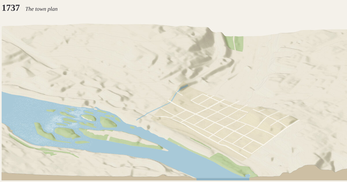
Downtown Richmond, from the Capitol to Tobacco Row, 1737. A frame 3 km across and 2 km deep (6.00 km²), centered on 37.5340°N, 77.4268°W.
The year 1737: The town plan how time is drawn →
William Mayo lays out Richmond for William Byrd II: a grid of squares east of Shockoe Creek, sold by lottery. Almost nothing standing today is this old.
Measured: 0 buildings standing today that had been built by 1737. Anything demolished since is missing unless traced or curated below.
Streets: a street is drawn only where a building of the year stood within reach of it or the town plan laid it out: 2,892 of today’s are left off. Whatever the era rules do not date (parks, cemeteries, dams, piers, parking aisles) is drawn in today’s scene only.
Curated for this year, from published sources; positions are drawn from today’s street grid and published dimensions, not surveyed:
- Byrd and Mayo's plan of Richmond, 1737 (1737–1769). William Mayo laid out the town for William Byrd II in 1737: a grid of two-acre squares east of Shockoe Creek, bounded by the river, today's 15th Street, Broad Street and 25th Street. (Encyclopedia Virginia gives 17th to 25th Street for the original blocks.) In the 1737 scene only the streets inside it are drawn. [1] [2] [3] [4]
- Shockoe Creek (open stream) (1737–1890). The creek ran open between present-day 15th and 16th Streets, dividing the town. A culvert begun in 1877 enclosed part of it, but the 1886 Sanborn map (volume 1, key map and sheets 18 and 19) still draws it open from Broad Street to the Dock, so it is drawn to 1890 (the end approximate). Course approximated as midway between the two streets. [1] [2]
The ground is today’s: cuts and fills since (the interstate, the floodwall) are in the elevation.
Camera how the camera works →
Looking north (bearing 351°), a fixed bearing with no snapping. Orthographic, tilted 30° down from the horizon: ground running into the picture is drawn at 0.5× its length and heights at 0.87×. 2 px per meter across the frame; the whole drawing is 6,048 × 2,642 px at 1:1.
Sources where the data comes from →
- OpenStreetMap: 313 features read from the cached download, shared with region
richmond-i195-rocketts. - USGS 3DEP elevation (United States (U.S. Geological Survey); bare-earth lidar, 1 m across most of the US, served by the National Map), fetched at 2 m per pixel and resampled to a 5 m grid. The ground runs from -0.1 m to 56.8 m above sea level (56.9 m of relief), drawn 2.5× taller than life. Buildings and bridges keep their true heights.
Ground what the ground is made of →
From the map, 31 mapped areas of water, islands, parks, woods and other cover, and 60 ribbons of road, path, rail, canal and weir. Painted in 200 strips from back to front, 10 m deep each, so hills hide what is behind them (why). Contours every 2 m with every 5th line heavier: 49,275 segments.
Rivers and rapids how rapids are read →
9,125 grid cells (about 22.8 ha) read as rapids: places on a river where its surface, recovered from the lidar, falls faster than 4 m per km along its channel, measured over 200 m. Rock standing more than 1 m clear of the water around it is drawn as boulders; lakes, basins and the sea get neither. Both are inferred from the lidar, not observed.
Buildings where heights come from →
0 buildings, extruded from footprints of at least 12 m² that lie wholly inside the frame, from OpenStreetMap.
- 0 (–) from a
heighttag - 0 (–) from the number of floors, at 3.4 m a floor
- 0 (–) guessed from the building’s type and size
Bridges how decks are placed →
No bridges in the frame.
Drawing paint order →
The paper palette, a dot on every visible corner, on a ground slab 18 m thick.
This build the archive →
Built November 17, 2026 in 7.0 s, 9.51 MB of SVG. From commit 01a2cb8, “Merge wave4-richmond-early: Richmond 1886, Then & Now and through time corrected (the canal and basin as water of their own, the river's bridges by year with the Free Bridge, the Seaboard and platforms dated, tall buildings sourced, print text); the published 1925 and 1950 scenes unchanged”.
Other measures: datedFromParcels 0, footprintsDrawn 0, plantingsLater 16, streetcarLines 0, streetcars 0, unbuiltStreets 2,892, vergesLater 64.
Map data © OpenStreetMap contributors (ODbL) · Elevation: USGS 3DEP (public domain) · credits and licenses